

The Ten Towers Trail


St Peter’s Church has one of the oldest round towers in Norfolk. Dating to the 11th century and containing much re-used Roman building material, St Peter’s stands isolated on a disused World War Two airfield, once the park to Haveringland Hall. The rest of the church, including the top of the tower, was rebuilt in 1858. It has some lovely glass and woodwork. The top of the font is medieval. Haveringland was the birthplace of ‘William of Norwich’. His mutilated body was found on Mousehold Heath in the 12th century and his murder was blamed (falsely) on the local Jewish community – the first so called ‘blood libel’. See if you can find the grave of a former gardener at Haveringland Hall (clue – it’s in the south east corner of the churchyard).
Distance to Brandiston Church less than a mile.

St Peter’s, Haveringland
1 -Walk back along the path to the road where you turn right. There are no paths here, so walk carefully along the right hand side of the road. The paths and some of the buildings around the area, including where you will be walking, were once part of RAF Swannington, the last airfield to be built in the Second World War.
2 – As the road bends right, cross over to see the stump of a medieval cross that once stood at a crossroads. Continue along the road and then turn left into Church Lane. After a few hundred yards, you will find Brandiston Church.
This is a flint church of Norman origins. Its distinctive short round tower is very much in contrast to the soaring towers of neighbouring Salle and Cawston. Large clear glass windows, some with medieval stained glass, illuminate the carved benches of the church which has lain almost untouched for over a century. The north aisle was originally the nave and contains traces of 12th century work. Look out for a tablet remembering Anthony and Preston Enright, sons of the Rector of Brandiston, who were both killed 18 months apart in the First World War, at the ages of 21 and 19 respectively.
Distance to Booton Church about 1 ½ miles.
St Nicholas, Brandiston
3 – On your right are Gurney Cottages, four almshouses built in the 1850s and owned by the Brandiston Gurney Charity, established from a 16th century bequest by William Gurney.
4 – On your left is Brandiston Common, surrounded by cottages that were originally built for labourers at Guton Hall and The Grove in Booton. Follow the road round and turn right into Grove Lane.
5 – Continue along Grove Lane until you reach four houses on your right. Opposite is a footpath across a field leading to Booton Church.
St Michael and All Angels Church in Booton was inspired by the Victorian work of Reverend Whitwell Elwin, who created a splendid ‘gothick’ pastiche drawing on examples of church architecture from across the land. It has three towers, one a minaret standing between the two taller ones. The church interior also features some excellent carpentry and coloured glass, featuring many angels, a precursor to the glories you will see at our next church. Don’t miss the priest’s door on the north side of the chancel.
Distance to Cawston Church around 1 ¼ miles.
St Michael’s, Booton
Leaving Booton Church turn right and then first left into Booton Lane. Continue along the lane until you reach Cawston Church.
 Roof angel in Cawston Church
St Agnes, Cawston
Roof angel in Cawston Church
St Agnes, Cawston
St Agnes, Cawston has a great tower, visible for miles, featuring unfamiliar stone in this land of flint and a top without pinnacles or battlements. Cawston church was rebuilt after the original west tower fell in a storm in 1412. Inside is one of the three best rood screens in Norfolk and home to perhaps East Anglia’s best group of roof angels who take flight from the wall posts and within the hammer beams. The Plough Inn sign in the church has a fascinating story to tell.
Distance to Salle Church around 2 ½ miles.
Leaving Cawston Church from where you arrived, turn right. Look out for a memorial to a Flying Fortress that crashed near here in World War Two on the church wall.
6 – Walk along the High Street passing the Village Hall on the right. You will reach a bridge over the Marriott’s Way footpath. Go down the steps to the footpath and turn left towards Reepham.
7 – After a mile keep an eye out for a metal sculpture/ seat on the left – opposite is a gap in the hedge and a footpath sign – follow this along the side of a field.
8 – At the end of the footpath, you reach a busy road. Taking care, cross over and turn left. Walking along the right side of the road you reach a junction where you follow the road round to the right and take the first left to find Salle Church.
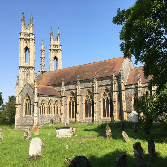
St Peter and St Paul, Salle was built during the 15th century, a replacement for an earlier building, Salle’s mighty tower with vast bell openings was topped with battlements and pinnacles on the very eve of the Reformation. There are many interesting details to see such as the set of nine wooden bosses that line the ridge of the chancel. See if you can find the brass inlay in the nave floor to Simon Boleyn, a priest, who died in 1489, and to the east of it a pair of brasses to Geoffrey and Alice Boleyn, great-grandparents to Anne Boleyn, second wife of Henry VIII.
St Peter and St Paul’s, Salle
9 – Leaving Salle Church, cross the road in front and walk beside the Village Hall next to the metal fire beacon. Follow the footpath next to the cricket pitch and practice nets round to the left. As the field opens, turn right along the field next to the conifer plantation.
10 – Follow the edge of the field looking out for an opening on the right as the field bends to the left, next to a road – take this opening and turn left.
11 – Continue to the edge of Reepham and see the old station yard on your right and the first of a few shops. Cross over the main road and walk towards The Crown pub and take the road on the right into the town. You will see Reepham Church facing you at the end of the road. Turn right to find the entrance to the churchyard on your left. The marketplace and public toilets are off to the right.
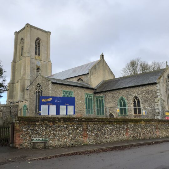
Here there are two church buildings in the churchyard, one hiding behind the other. The most prominent overlooking the old marketplace was the parish church of Whitwell, the one behind the parish church for Reepham. Once there were three churches in this churchyard – the remains of the third (Hackford) survives to the south of Whitwell church. This three-in-one churchyard is in the centre of town as it may have been convenient in ancient times for churches to share consecrated ground. Look out for the Royal Arms of George II – they carry a pivotal date in English, Scottish and Irish history – 1745 – Charles Stuart’s attempted coup d’état.

St Mary’s, Reepham
12 – Leaving Reepham Church take the path in front of you across the churchyard to Church Street and turn right. As the road bends right, you will see opposite a brick arched entrance to a footpath and the sign for Back Street – go through this archway and follow the path.
13 – At the end of the footpath turn left along the road coming in from the right. Follow this road and continue along it continuing along the stretch marked with a ‘No Through Road’ sign.
14 – As the road bears round to the right a footpath sign on the left points through a gate – follow this route through the gate and across fields and woods.
15 – When you reach the road turn right and follow for about a mile to reach Great Witchingham Church.
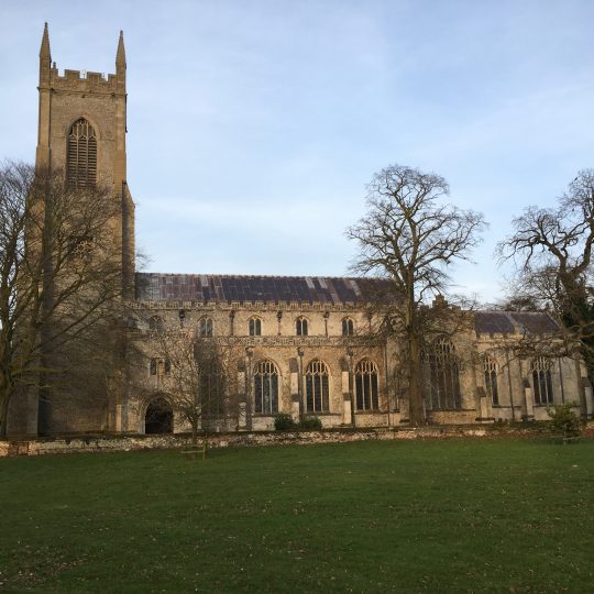
St Mary’s Church fits snugly into the churchyard, not large, but with the aisles and clerestory reflecting the money lavished in the late medieval period. The star of the show is the late 15th century font, one of the best of East Anglia’s thirty-odd Seven Sacrament series. The dedication of the church is to the Assumption of the Blessed Virgin, one of the most common medieval dedications in East Anglia. The star of the show is the late 15th century font, one of the best of East Anglia’s thirty-odd Seven Sacrament series. Look out for the original colour it retains, mostly red
and green. And you can’t miss the eagle lectern – what a bird! It was brought here from New College, Oxford in the 19th century, and was used as the pulpit before the present, simple one came in 1974.
Distance to Little Witchingham Church around 1 mile.

St Mary’s, Great Witchingham
16 – Leaving the church, turn right onto the same road you arrived on. Follow this road to reach Little Witchingham Church in Church Road, ignoring the two turnings off to the right.
St Faith, Little Witchingham was built in the first half of the 14th century. Witchingham has always been a tiny parish and the church shared a minister with Great Witchingham after the Reformation. One summer’s day in 1967, an enthusiastic art historian found the church ruinous, roofless, and full of elder and ivy. The story goes that she climbed in through one of the empty windows, began stripping away ivy and found that the whitewash came off it, revealing marvellous things. Thanks to the Norfolk Churches Trust, a plan of repairs was put in place, and one of England’s most exciting schemes of wall paintings was excavated in the early 1970s. The church is in the care of the Churches Conservation Trust. Can you
find a ram caught in a thicket on the south aisle?
Distance to Alderford Church around 2 miles.

St Faith’s, Little Witchingham
17 – Leaving the church along the road you arrived on take the second turning on the left into Springwell Lane.
18 – At the end of the road turn left. In front you will see Great Witchingham Hall where Bernard Matthews began his turkey business in the 1950’s. Be careful along this road as it narrows and carries lorries. You will reach Alderford Church on the left in about half a mile.
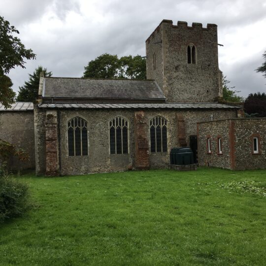
St John the Baptist, Alderford was built in the first half of the 14th century, and later in that century a bequest brought the porch; and then finally the topping of the tower parapet with finials, was thought to be an 18th century addition. Dominating the southern end of the church is one of the most memorable of England’s thirty-odd Seven Sacrament fonts, imposing in this small space, its reliefs characterful and retaining traces of original paint. How many of the sacraments can you recognise?
Distance to Swannington Church around 1 mile.

St John the Baptist’s, Alderford
19 – Leaving the church via the same road you arrived on you will reach a junction. Turn left and cross over to find a path on the verge. After a few yards turn right where you see a footpath sign taking you across a field.
20 – Having crossed two fields, you will see an opening in the hedge and a bridge over a ditch – follow this alongside a fence enclosing an orchard.
21 – As you come to a choice of footpaths go right beside the barn, through a metal gate and up a concrete track beside farm buildings. Follow the blue sign for Swannington Church.
St Margaret, Swannington has a massive tower that is matched by an interior which features richly coloured glass, especially the east window which features heads of flowers with exhortations to Seek the Lord and Watch and Pray. Above the porch arch we find two carved scenes. The one on the left shows a fat dragon with two bemused onlookers. On the right, the dragon is dead, the people are happy, and an armoured female looks triumphant. These are scenes in the life of St Margaret, an unusual thing to find.
Distance back to Haveringland Church around 2 ½ miles.
St Margaret’s, Swannington
22 – Leaving the churchyard turn left into Church Lane. Once past Swannington Hall (on your right) the road bends to the right. Look out for a footpath sign on the left along an avenue of trees. Follow this path alongside fields for about three quarters of a mile crossing over a concrete farm track.
23 – You approach a fence with a rickety stile – go over this and cross the field in front aiming for the edge of a woodland (Six Acre Plantation) ahead of you.
24 – At the edge of the field find a footpath sign pointing back where you have come from and turn left on Mill Lane. A Water Mill and Mountjoy Priory used to be located off this road to the right. Follow this road then Haveringland Road back to Haveringland Church.
Congratulations, you’ve made it!
Written by Nigel Boldero and Eliza Greenwell
Share


